
Tsunami Evacuation Routes Papamoa & Papamoa East


Timeline:
August 2024 The Papamoa Tsunami Story Upodated. Click to read Sent to the Mayor and all Councillors. Response was muted.
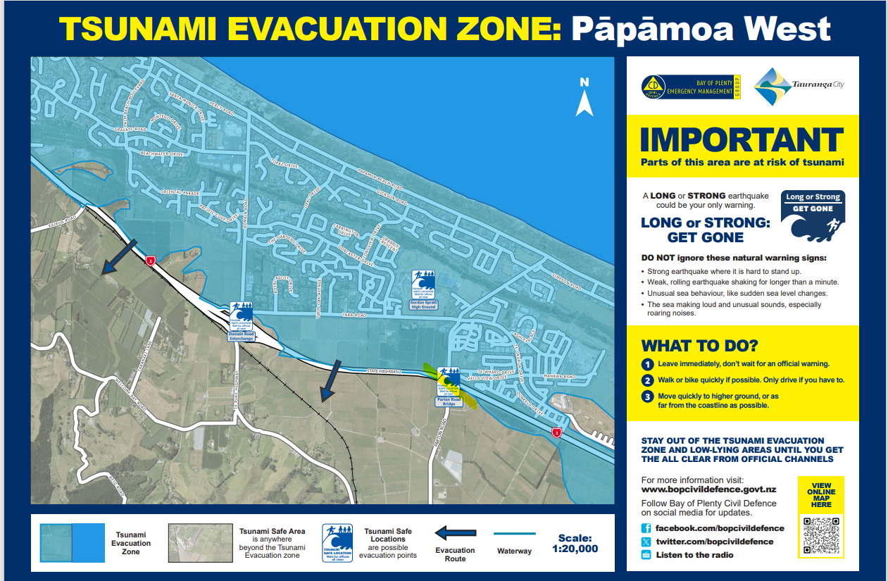
UPDATED OCTOBER 2023 - new Tsunami Maps issued by TCC. There is only one colour — blue — which means you are under water and must evacuate. The Tsunami Maps are below.
Where do you go when the Tsuanami Evacuation is broadcast? To higher ground or at least 4 km away from the coast. Higher ground is 20m above sea level and on the inland side of the expressway. There will be 35,000 people all evacuating at the same time.
You will need to move by foot and bike, the roads will be jammed with people trying to escape. Remember the chaos and grid lock of the false alarm in Feb 2021.
The current Tauranga City Council evacuation routes are incomplete and do not cross the expressway to the safer higher ground. eg Papamoa Hills.
The proposed commuter cycle way alongside the expressway could connect all the evacuation paths and distribute evacuees to crossing points over the expressway. More crossing points need to be built. This will provide the link to the safety areas of higher ground.
See below for the map showing express cycleways and tsunami escape routes.
ONE OTHER MISSING LINK — THERE ARE NO FOOTPATHS ON DOMAIN RD between Gravatt Rd and crossing under the TEL (expressway), a major escape route.
The newer areas of Papamoa East and the Sands shopping mall area are also locked in by the expressway (TEL). The new (currently being built) bridge at the Papamoa Eastern Interchange(PEI) is the only easy access across the TEL (Tauranga Eastern link) and moving to higher ground.
Sadly, at present there are no council plans to use this bridge to provide easy pedestrian access to the other side of the expressway and onto Bell Rd . See PEI Bridge page.
Link to video showing Japan 2011 tsunami wave. Watch this video to see the volume of water that never seems to stop.
Another link. Listen to the emergency sirens in the video.


The existing tsunami evacuation routes will lead to the commuter cycleway (shown in black) which then is an easy path to higher ground or crossing the expressway. These tsunami paths will also be access to the cycle way everyday.
(Where are the) Tsunami Escape Routes from Papamoa to Papamoa Hills. What would you do????
Excerpt from the Chairmans Address PRRA June 2023 Meeting.
I would like to start tonight’s meeting with a Role Play.
While you were coming here tonight for the meeting, there was a large movement of the earth plates in the Kermadec Trench. One plate released itself from the overlying plate with the release of tremendous energy, producing a massive earthquake. This caused millions of tons of seabed to collapse into the Trench and this has produced a tsunami wall of water heading towards the NZ coast including Papamoa. You felt nothing, it was too far away.
It will take at least one hour for the Tsunami Emergency Mobile Alert team to assemble in Wellington. They will examine the data, work through some protocols, make a decision, probably need Ministerial input before an Emergency Warning can be issued to New Zealand via cellphone. Time is going on.
If you have your cell phone on and close by, you will hear the unforgettable squawking noise the cell phone makes when this warning is given.
You read the message in disbelief, is this real or a false positive. You listen for the emergency sirens to confirm, after all 75% of NZ has emergency sirens, but Papamoa does not have emergency sirens. The previous council approved the sirens and the money was in the budget ready for installation. However, the commissioners canned the sirens. ??????
Already you can hear increased traffic on the road outside. What to do, where to go, quick look up the council website for information;
“Walk to safety, roads will be gridlocked”.
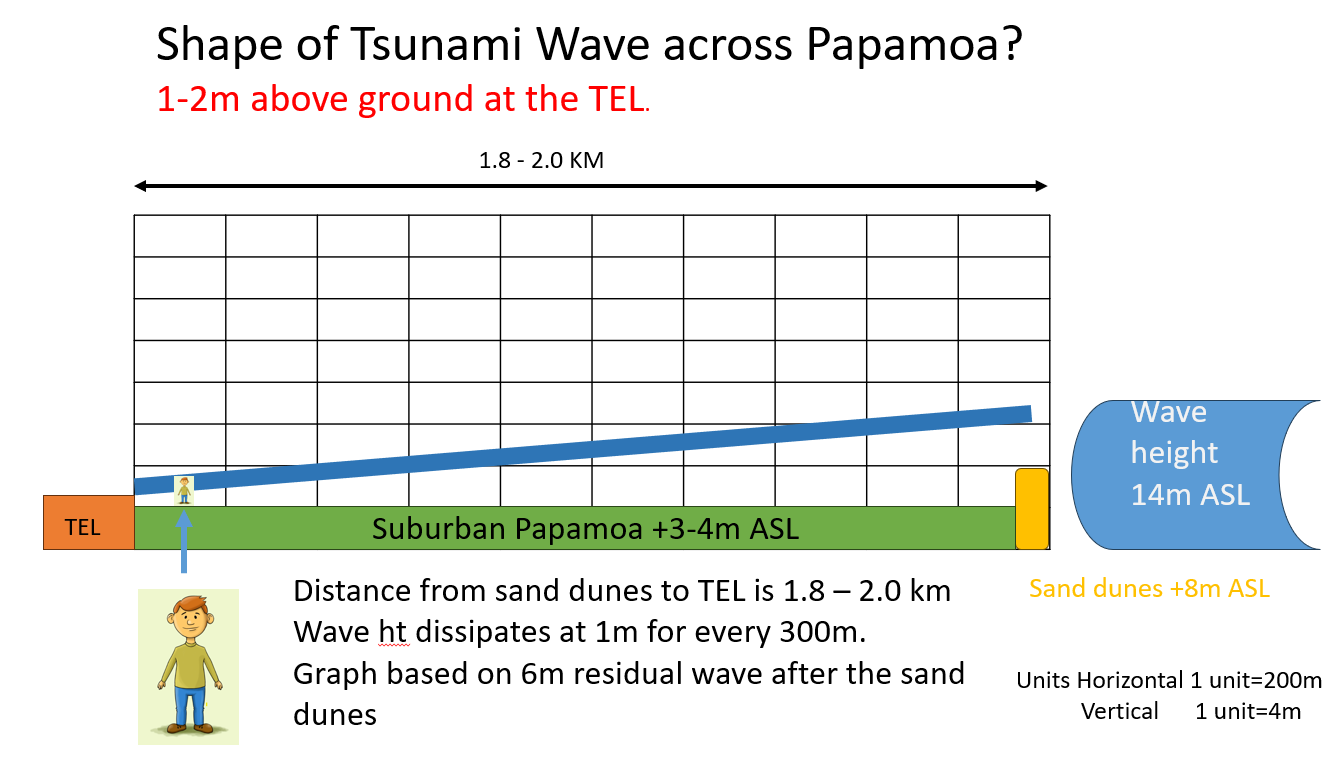
Where is Safety , look at the coloured map of Papamoa on the council website. Papamoa is shaded in yellow or orange. But, the expected tsunami water wall is 14-18m tall above sea level, Papamoa is 3-4 m above sea level and Papamoa is flat. What difference is an orange colour v the yellow colour. Green is the only safe colour.
We need to get to higher ground, to the Papamoa Hills on the other side of the TEL (expressway). How do we get there, where do we cross the expressway. It’s dark out there now.
Listening outside the traffic is stationary, gridlock has happened. The only escape is now on foot or by cycle.
There are no easy to find and easy to use pedestrian escape routes from Papamoa to the Papamoa Hills. How is this possible, we have known about this risk for years. You can not believe this. It is putting the population at high risk of death.
PRRA along with Eastern Corridor Alliance has put forward a plan of escape routes alongside the TEL fed by finger escape routes from the housing areas. These can be built tomorrow. At a cost less than $25 million.
See the map above showing the expressway, escape/cycle path alongside and the red crossings over the expressway. Note the PEI crossing is not functional.

Tsunami Escape Routes Follow up cont ( from the Tonkin & Taylor Report )
“Would inundate parts of Mauao & Wairakei within 60mins. “
A pedestrian-based evacuation network was developed using the existing roading network, walkways, reserves and cycleways to reach safe areas. It was vital that evacuation stations could be reached quickly, on foot, as NZTA modelling revealed vehicular traffic would gridlock the roads within minutes. Footbridges along the evacuation route were designed and built to Importance Level 4. Sixteen safe assembly locations were developed at strategic points. Some use distance to keep residents safe, while Vertical Evacuation Stations employ the raising of land (earth bunds) and are the first of their kind to be constructed outside of Japan and Pacific North-West America.
In 2017, this project was officially recognised for excellence when it picked up the Civil Defence Emergency Management "Directors Award" for “exceptional innovation/creativity that has pushed the boundaries of current CDEM practice in NZ”.